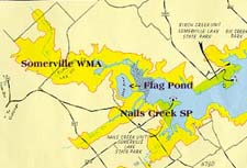
Somerville WMA / Flag Pond / Lake Somerville
State Park - Nails Creek Unit
© Bert Frenz, 1997
Perhaps because this area is so hard to find, the Somerville
Wildlife Management Area is largely ignored by birders and other wildlife
enthusiasts. Yet it offers the best of birding in southern Burleson County and northern
Lee County. Midway between College Station and Austin, both Rio Brazos Audubon and Travis
Audubon Societies have sponsored trips to the area. In fact, Travis Audubon Society
maintains hiking trails through the dense wetlands. Biologist Jim Yantis has marked 56
species of trees, vines and shrubs along the two loop trails and Doug Booher from Austin
regularly sets mist nets near the trails. Flag Pond can be reached
by road and a short hike - the directions are given below. The pond can also be
reached by hiking from Nails Creek State Park or from Birch Creek State Park. Flag
Pond is about midway on the 13-mile trail which can easily be navigated by mountain bike
or horseback.
If you can manage the sticky hot days of late spring, summer and
early fall, Somerville WMA is the site to visit for nesting species, including Red-shouldered
Hawk, Yellow-billed Cuckoo, Bared Owl, Pileated Woodpecker, Acadian Flycatcher, Gray
Catbird, White-eyed Vireo, Red-eyed Vireo, Northern Parula, Swainson’s Warbler,
Common Yellowthroat, Summer Tanager and Indigo Bunting. In spring migration it
is regularly visited by warblers, grosbeaks and buntings. The dead snags are
favorite perches for Olive-sided Flycatcher. Along the hiking trails you can hear
the goose-like calls of Green Tree Frogs and the Sandhill Crane-like sounds of Gray
Tree Frogs, discover Gulf Coast Toad and lots of Red Stripe Pond Sliders
and be on the lookout for a Copperhead.
 To get to Somerville WMA, there is a more or less direct way
and there is a scenic way more amenable to bird sightings. Here are directions for the
scenic way in and the direct way out. In College Station, from the Texas & University
Av intersection, travel southwest on University past FM 2818 (milepost 2.6), continuing on
FM 60 toward Somerville. At milepost 23 turn right (NW) on State 36 toward Lyons,
traveling only ˝ mile and turning left on FM 60 again toward Deanville. During this
stretch of wooded pastures, watch for Cattle Egrets and Crested Caracara. At
milepost 33.5 (Koehler's Korner) turn right to continue on FM 60. In Deanville turn left
(south) on FR 111 (milepost 39), which later becomes CR 133, and then turn right on CR134
(milepost 46). This last turn is easy to miss because it looks like you are entering a
private ranch - actually you are driving through Zgabay Ranch. Check the tank on the right
for wading birds. At milepost 47 you will cross the East Yegua Creek into Lee County and
the road becomes Red Hill Road or County 430. Enter the Wildlife Management Area at
milepost 48 on your left and head to one of the two parking lots. The first one is on the
gravel road exiting to the right and the second one is straight ahead at the end of the
oil field access road. In the corner of the first parking lot, near the fresh water
outlet, is a box often containing trail guides. You can start hiking here for wooded
species or you can walk the gravel road for more open marsh birds. From the parking lot at
the end of the road, you can reach the hiking trail by walking through the field at the
far right corner, heading toward the woods. A suspension bridge takes you across the
Middle Yegua Creek and the start of the Interpretive Trail. If you want to get to some of
the other areas on this itinerary, limit your stay here to a few hours.
To get to Somerville WMA, there is a more or less direct way
and there is a scenic way more amenable to bird sightings. Here are directions for the
scenic way in and the direct way out. In College Station, from the Texas & University
Av intersection, travel southwest on University past FM 2818 (milepost 2.6), continuing on
FM 60 toward Somerville. At milepost 23 turn right (NW) on State 36 toward Lyons,
traveling only ˝ mile and turning left on FM 60 again toward Deanville. During this
stretch of wooded pastures, watch for Cattle Egrets and Crested Caracara. At
milepost 33.5 (Koehler's Korner) turn right to continue on FM 60. In Deanville turn left
(south) on FR 111 (milepost 39), which later becomes CR 133, and then turn right on CR134
(milepost 46). This last turn is easy to miss because it looks like you are entering a
private ranch - actually you are driving through Zgabay Ranch. Check the tank on the right
for wading birds. At milepost 47 you will cross the East Yegua Creek into Lee County and
the road becomes Red Hill Road or County 430. Enter the Wildlife Management Area at
milepost 48 on your left and head to one of the two parking lots. The first one is on the
gravel road exiting to the right and the second one is straight ahead at the end of the
oil field access road. In the corner of the first parking lot, near the fresh water
outlet, is a box often containing trail guides. You can start hiking here for wooded
species or you can walk the gravel road for more open marsh birds. From the parking lot at
the end of the road, you can reach the hiking trail by walking through the field at the
far right corner, heading toward the woods. A suspension bridge takes you across the
Middle Yegua Creek and the start of the Interpretive Trail. If you want to get to some of
the other areas on this itinerary, limit your stay here to a few hours.
 Our next stop will be
Nails Creek State Park and Flag Pond. As you exit from Somerville
WMA, turn left on to Red Hill Road; we will assume your odometer now reads approximately
49 miles, but it may vary a bit by now. After a quarter mile you will be turning right
(northwest) continuing on Red Hill Road toward Dime Box. At milepost 51 turn left (south)
on FM 141 and after another mile turn left (east) again on FM 1697. At milepost 57 the
road forks. The left branch is 125 (old 1697) and is an alternative way to reach Flag
Pond. If you aren’t already bewildered by all these directions, take 125 and you
surely will be confused. A wiser choice is to take the right branch and continue on 1697.
Both sides of FM 1697 offer interesting habitat that has produced sightings such as White
Ibis, Acadian Flycatcher and White-winged Dove. Continue to milepost 60 where
the road intersects FM 180. Turn left toward Nails Creek Unit of Lake Somerville State Park. After a mile or two
you will see D’s Diner on the left. If you are ready for a break, D’s offers
rest rooms, drinks and good hamburgers. It often looks like it is closed, but it probably
is not. Continuing on FM 180, travel only a half-mile to where we again intersect FM 125
and turn left (milepost 62). Shortly you will intersect Nails Creek and at milepost 63 or
64 turn right on a narrow oil service road labeled PR 1254. Although this road
does lead eventually to Flag Pond, it crosses private property. Instead,
continue on FM 125, turn left on FM 180, continuing another 1.6 miles to reach
Nails Creek State Park. The park offers a variety of birding opportunities
to choose from. In order of productivity, try the cliff lookout from the picnic
area to scan for waterfowl on Somerville reservoir, the marshy area near the
boat ramp, the view of swallow waters from the second picnic area near the scout
area, and the hiking/nature trail through the thick woods. Bald Eagles are regularly seen near the shore and out-of-season reports of
ducks, gulls and terns are most likely to originate from this park. From the
park you can hike to Flag Pond. Head toward the ancient
and enormous Live Oak at the top of the hill. The skies here are often filled with soaring
birds and, in fall migration, this is a great site for soaring Mississippi Kites.At
the top of the knoll you have a panoramic view of Flag Pond.
Our next stop will be
Nails Creek State Park and Flag Pond. As you exit from Somerville
WMA, turn left on to Red Hill Road; we will assume your odometer now reads approximately
49 miles, but it may vary a bit by now. After a quarter mile you will be turning right
(northwest) continuing on Red Hill Road toward Dime Box. At milepost 51 turn left (south)
on FM 141 and after another mile turn left (east) again on FM 1697. At milepost 57 the
road forks. The left branch is 125 (old 1697) and is an alternative way to reach Flag
Pond. If you aren’t already bewildered by all these directions, take 125 and you
surely will be confused. A wiser choice is to take the right branch and continue on 1697.
Both sides of FM 1697 offer interesting habitat that has produced sightings such as White
Ibis, Acadian Flycatcher and White-winged Dove. Continue to milepost 60 where
the road intersects FM 180. Turn left toward Nails Creek Unit of Lake Somerville State Park. After a mile or two
you will see D’s Diner on the left. If you are ready for a break, D’s offers
rest rooms, drinks and good hamburgers. It often looks like it is closed, but it probably
is not. Continuing on FM 180, travel only a half-mile to where we again intersect FM 125
and turn left (milepost 62). Shortly you will intersect Nails Creek and at milepost 63 or
64 turn right on a narrow oil service road labeled PR 1254. Although this road
does lead eventually to Flag Pond, it crosses private property. Instead,
continue on FM 125, turn left on FM 180, continuing another 1.6 miles to reach
Nails Creek State Park. The park offers a variety of birding opportunities
to choose from. In order of productivity, try the cliff lookout from the picnic
area to scan for waterfowl on Somerville reservoir, the marshy area near the
boat ramp, the view of swallow waters from the second picnic area near the scout
area, and the hiking/nature trail through the thick woods. Bald Eagles are regularly seen near the shore and out-of-season reports of
ducks, gulls and terns are most likely to originate from this park. From the
park you can hike to Flag Pond. Head toward the ancient
and enormous Live Oak at the top of the hill. The skies here are often filled with soaring
birds and, in fall migration, this is a great site for soaring Mississippi Kites.At
the top of the knoll you have a panoramic view of Flag Pond. 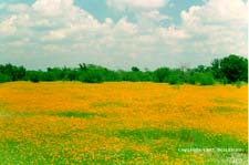 Spotting scopes are valuable
here and with patience and a good day you may see American White Pelican, Snowy Egret,
Little Blue Heron, White Ibis, White-faced Ibis, Roseate Spoonbill, Wood Stork and a
variety of ducks. Depending on the water level, shorebirds may be using exposed mud flats.
If you want to make a day of Flag Pond alone, you can camp at Nails Creek State Park and
hike, bicycle or horseback ride to and around the pond and even continue to Birch Creek
State Park. In the spring the hillsides and meadows surrounding Flag Pond are brilliant
yellow with daisy-like Coriopsis.
Spotting scopes are valuable
here and with patience and a good day you may see American White Pelican, Snowy Egret,
Little Blue Heron, White Ibis, White-faced Ibis, Roseate Spoonbill, Wood Stork and a
variety of ducks. Depending on the water level, shorebirds may be using exposed mud flats.
If you want to make a day of Flag Pond alone, you can camp at Nails Creek State Park and
hike, bicycle or horseback ride to and around the pond and even continue to Birch Creek
State Park. In the spring the hillsides and meadows surrounding Flag Pond are brilliant
yellow with daisy-like Coriopsis.
Depending on how much time you have left for birding, you can
continue around the south side of Lake Somerville, stopping at Rocky Creek Park, Yegua
Creek Park and Overlook Park, or you can take the quick way home via Caldwell. For the
Caldwell route, exit Nails Creek Unit on FM 180, turn right on FM 1697 toward Dimebox. When you intersect FM 141, head toward Dimebox and after passing through the
small town you will encounter State Highway 21. Turn right (northeast) toward Caldwell and
continue until you reach Bryan.
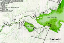
Map of
Nails Creek Unit of Lake Somerville State Park
Map of
Birch Creek Unit of Lake Somerville State Park
Return to Finding Birds in the Heart of Texas