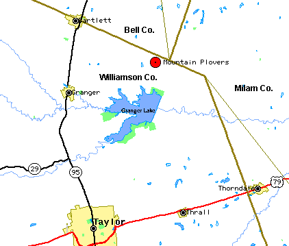
Alcoa Lake & Granger Lake
© Bert Frenz, 1998-2004
These two lakes and the surrounding areas make an interesting day
trip whether starting from College Station or Austin. Alcoa Lake, near Rockdale in
Milam County, offers great quantities and varieties of ducks,
occasionally rare gulls (e.g. Sabine's Gull) and a variety of
out-of-season surprises. Granger Lake in Williamson County has the reputation of a
great spot for Mountain Plover, Sprague's Pipit and
several longspur species, particularly Chestnut-collared Longspur, Lapland
Longspur and McCown's Longspur. The huge expanse of open
farmlands are home to thousands of meadowlarks which seem to be about 90-98% Western
Meadowlarks. Horned Larks also enjoy this habitat.
Willis Creek Park on Granger Lake is a great spot for finding 13 or 14 sparrow species,
including Harris' Sparrow and LeConte's Sparrow.
Much of the good birding at Alcoa Lake can be done
without entering the Alcoa plant. But don’t let that stop you. The company is
friendly toward birders - don’t use your camera, however - and provides access to
good habitat around the lake. To bird the restricted area, follow the guide below to
Milepost 154.5. Then continue approximately 0.2 mile further and register at the
Visitor’s Center. If you are birding on a Sunday or federal holiday, the
Visitor’s Center is closed and you need to look behind this building at a nondescript
one-story building marked "Plant Protection Office." It is about 100 yards off
the road and is not obvious. The best times to bird Alcoa Lake are weekends and
holidays.
 The Granger itinerary is complex because so many county roads
weave almost randomly through the sorghum fields and the lake area hides many wildlife
management areas that are not obvious to locate. The following table hits all the
key areas and marks where unusual species have been sighted in the past. There is
insufficient time in one day to make all the birding stops, so plan your trip accordingly.
You will need to leave Milepost 129.2 by 3 P.M. to allow enough time for a brief
visit to Alcoa Lake.
The Granger itinerary is complex because so many county roads
weave almost randomly through the sorghum fields and the lake area hides many wildlife
management areas that are not obvious to locate. The following table hits all the
key areas and marks where unusual species have been sighted in the past. There is
insufficient time in one day to make all the birding stops, so plan your trip accordingly.
You will need to leave Milepost 129.2 by 3 P.M. to allow enough time for a brief
visit to Alcoa Lake.
Starting from College Station -- use the chart as
given
Starting from Austin -- head northeast toward
Taylor, then take Texas 95 north for 18.7 miles to Circleville. From here, pick up
the itinerary at Milepost 107.5 on the chart below. Continue forward on the chart to
cover the south side of Granger Lake or read the chart in reverse to head around the north
side of Granger Lake.
Starting from Waco and points north -- take I-35 to
Georgetown, then FR 971 to Granger. Continue on FR 971 until you join the itinerary
at Milepost 95.3 and decide whether you want to use the chart forwards or backwards.
Starting from Houston -- take I-10 or US 290 to
Texas 95, continue north to Taylor and then another 18.7 miles to Circleville. From
here, pick up the itinerary at Milepost 107.5 on the chart below. Continue forward
on the chart to cover the south side of Granger Lake or read the chart in reverse to head
around the north side of Granger Lake.
Satellite photo - see Terraserver site
Additional maps -- successive maps zoom in on a
previous one.
Alcoa Lake: (largest area) Map A1 Map A2
(smallest area)
Granger: (largest area) Map G1
show above Map G2
Map G3
Map G4
(smallest area)
Report your sightings -- please report you
sightings to Bert Frenz for inclusion in his RBA,
NAB and
TOS reports.
Itinerary for Alcoa Lake, Granger Lake and surrounding areas
Milepost |
Action |
Location |
Notes |
0.0 |
start
at |
Texas
Av & University Dr |
College
Station, Brazos County |
0.0 |
head
east on |
University
Dr. (FM 60) |
|
1.8 |
turn
left (north) on |
Texas
6 (bypass) |
|
6.5 |
cross |
Texas
21 / US 190 |
|
26.8 |
turn
left on |
US
79 (south) |
in
Hearne |
32.0 |
cross |
Brazos
River |
entering
Milam County |
57.6 |
turn
right on |
FM
487 (west) |
in
Rockdale |
79.5 |
turn
left on |
CR
422 |
before
reaching Davilla |
79.7 |
turn
left on |
CR
422 |
gravel
road, mesquite habitat, see -------- Map G3 ---------- |
82.1 |
turn
right on |
Alligator
Rd. |
cattle
pastures & wooded edges. Jet-black dark-morph Red-tailed Hawk found from here to the
"T". Latitude = 30 45' 31" (30.7552); longitude = 97 18' 29"
(-97.3048) |
80.5 |
cross |
Alligator
Creek |
entering
Bell County |
84.1 |
turn
left on |
Alligator
Rd. |
sign
post says "Althea LP." |
84.2 |
birding
stop at |
"T"
at Alligator Rd. and Friendship Rd. Latitude = 30 45' 48" (30.7580); longitude
= 97 19' 40" (-97.3233) |
Start
looking for longspurs, especially Chestnut-Collared Longspurs. |
84.2 |
turn
left on |
Friendship
Rd. |
Mountain
Plovers from the "T" south to the curve. |
84.5 |
road
becomes |
CR
360 |
entering
Williamson County |
85.2 |
birding
stop at |
curve.
GSS Latitude = 30 45' 02" (30.7503); longitude = 97 19' 58" (-97.3263).
For use on Tiger Maps these correspond to 30.750 and -97.332 |
Mountain
Plovers most often seen here. Best time seems to be early morning. Longspurs sometimes fly
over this spot.
---------Map G4---------- |
85.7 |
turn
right on |
CR
359, "T" |
Burrowing
Owl seen here |
87.1 |
turn
right on |
FR
971 (west) |
|
87.5 |
birding
stop at |
Friendship
Park |
on
Granger Lake, US Army Corp of Engineers, $3 entrance fee, usually waived for birding.
No fee in winter. |
87.5 |
continue
on |
FR
971 (west) |
|
88.3 |
birding
stop at |
Sore
Finger Wildlife Area (to the left on the extension of CR 358) Lat.
N 30 43' 47" and Long. W 97 21' 04" |
Granger
Lake WMA - Sore Finger Unit, Texas Parks & Wildlife Dept, Short-eared Owl found here |
88.3 |
continue
on |
FM
971 (west) |
along north side
of Granger Lake |
90.5 |
birding
stop at |
Willis
Creek Wildlife Area (across from tower with large white sphere) |
Granger
Lake WMA - Willis Creek Unit, Texas Parks & Wildlife Dept |
91.9 |
turn
left on |
CR
349 (south) |
gravel
road along WMA |
92.9 |
turn
right on |
same
road |
gravel
road makes two right-hand turns and returns to FM 971 |
94.7 |
turn
left on |
FM
971 (west) |
|
95.3 |
turn
left on |
CR
348 (south) |
Beard
Manchu Allison cemetery |
95.6 |
cross |
CR
347 (on right) |
Say's
Phoebe seen from here to Willis Creek Park. Also Red-shafted Flicker. |
96.5 |
birding
stop at |
Opposum
Creek |
Granger
Lake WMA - Opposum Creek, parking lot and trail along the creek, good wooded habitat |
96.5 |
continue
on |
CR
348 (south) |
look for sparrows
& Bewick's Wren |
98.3 |
birding
stop at |
Willis
Creek Park |
on
Granger Lake, US Army Corp of Engineers, $3 entrance fee, usually waived for birding,
great spot for sparrows, including Harris' and LeConte's, Spotted Towhee. RV
and tent camping is available here. |
98.3 |
double
back on |
CR
348 (north) |
|
99.2 |
turn
left on |
CR
346 (west) |
Mountain
Plover seen in fields. |
100.0 |
cross |
CR
347 |
Mountain
Plover seen in fields. |
101.1 |
turn
left on |
CR
345 (south) |
Mountain
Plover seen in fields. |
103.3 |
turn
left on |
CR
347 |
|
104.7 |
birding
stop at |
San
Gabriel Wildlife Area |
Granger
Lake WMA - San Gabriel Unit, Texas Parks & Wildlife Dept, parking lot, primitive boat
launch (canoeing?) |
104.7 |
double
back on |
CR
347 |
|
106.1 |
turn
left on |
CR
347 (west) |
|
106.5 |
turn
left on |
Texas
95 (south) |
|
107.5 |
cross |
CR
374 |
Circleville,
lunch?, meeting place?, Great-tailed Grackles |
107.7 |
turn
left on |
FR
1331 (east) |
along
south side of Granger Lake |
111.3 |
turn
left on |
CR
496 (on left) |
water
treatment plant |
111.3 |
birding stop at |
Comanche Park |
good for wintering
sparrows |
112.5 |
birding
stop at |
Taylor
Park |
on
Granger Lake, US Army Corp of Engineers, $3 entrance fee, usually waived for birding |
114.2 |
turn
left to |
Wilson
H. Fox Park |
on
Granger Lake |
114.9 |
birding
stop at |
overlook |
ducks |
114.9 |
birding
stop at |
cattail
marsh below south spillway of dam |
Sora,
Say's Phoebe, Marsh Wren, yellowthroat, Swamp and LeConte's Sparrows |
116.1 |
birding
stop at |
spillway |
cormorant,
herons |
117.3 |
birding
stop at |
Prairie
Replication Site |
Wild Turkey |
117.5 |
turn
left on |
FM
971 (west) |
|
118.5 |
cross |
CR
360 |
We've
completed the loop around Granger Lake. If short on time turn right here and head
back the way you came until Alligator Rd. Pick up on this table at Milepost 129.2.
If you picked up the itinerary at Circleville and haven't seen the Mountain
Plovers, make this right turn also and follow from Milepost 87.1 backwards. |
121.8 |
pass |
Willis
Creek Wildlife Area (across from tower with large white sphere) |
|
122.4 |
turn right on |
CR 352 |
|
122.6 |
cross |
CR 357 (on right) |
longspurs sighted
here |
124.9 |
slow
down at |
CR
353 |
longspurs sighted
here to Alligator Rd. |
126.4 |
birding stop at |
left on Alligator
Rd. |
Mountain Plovers
seen here early in the 1998 season and again in 1999. Nicknamed the
"megafield." |
126.4 |
turn
right on |
Alligator
Rd. |
Sprague's
Pipits along this road |
129.2 |
cross |
"T"
at Alligator Rd. & Friendship Rd. |
we've finished the
loop and are now headed back to Milam Co. |
129.3 |
continue right at |
Althea LP signpost |
still on Alligator
Rd. |
131.8 |
turn left on |
CR 422 |
Milam County |
133.9 |
turn
right on |
FR
487 (east) |
at
Davilla |
139.3 |
turn
right on |
FR
3061 |
toward
San Gabriel |
143.3 |
turn
right on |
FR
486 (south) |
in
San Gabriel |
149.8 |
turn
left on |
US
79 (north) |
in
Thorndale |
157.3 |
turn
right on |
FR
1786 |
bird
woods beside road to Alcoa Lake --------- Map A1---------- |
161.2 |
birding
stop at |
Alcoa
Lake |
bird
marsh on right and bay on left for herons, ducks, yellowthroats, wrens --------- Map A2---------- |
162.2 |
turn
left at |
Alcoa
power plant |
|
162.4 |
birding
stop at |
pond,
Lat. N 30 34' 09" Long. W 97 04' 23" |
100's
of ducks |
162.8 |
birding
stop at |
hot
water runoff |
night-herons,
cormorants |
|
birding
stop at |
Alcoa
Lake |
To
bird more around the lake, continue to the Visitor's Center or Security Office. (See
details above). |
231.3 |
return
to C.S. |
Texas
Av & University Dr. |
|
Other areas where plovers, longspurs and pipits have been sighted:
Mountain Plovers
M-1. South of CR 124 (labeled 338 on many maps) and CR 340
(labeled 337 on many maps). This is west of Texas 95. From the intersection of
Texas 95 and Texas 29 travel north for about 2 miles, turn left (west) on CR 124, continue
for 2-3 miles until you reach CR 340.
Longspurs
L-1. On CR 192 which is 0.6-0.7 miles north of Texas 29.
L-2. On CR 127 just west of its intersection with CR 192.
L-3. On the hill near the intersection of CR 124 and CR 341.
L-4. CR 158.
Sprague's Pipits
S-1. On CR 124 one-half mile west of Texas 95
S-2. CR 192 between Granger and Round Rock
Return to: Birding in Central Brazos Valley
This page was last updated
December 15, 2004.