Chapter 15. Dempster Highway
Day 95 - August 18 ñ Dempster Highway to Eagle Plains
(Shari) The discussion to make the run up the 450-mi. gravel Dempster Highway
is a roller coaster of yeas and nays. We hear varying reports about the roadís
condition and people drop out of the trip until only six brave and tough couples
are willing to take the risk. (This is the beauty of an ala carte trip: you only
pay for segments you do.) Bill and Ginny are the bravest as they are willing to
take their 5th-wheel. None of us with Class A motor homes (including Bert and
me) want to drive them. Four couples intend to sleep in their cars on the way up
(including Bert and me) and one has motel reservations at all nightly stops. I
bought a sleeping bag in Anchorage for this purpose and we already have an air
mattress that fits just perfectly in the back of the car when the back seats are
folded down. One thing we hear over and over: ìThe Dempster is in its worst
condition everî because of all the rain this summer. As I peek out my window
this morning, I see more rain. Just one person has to say ìLetís not goî and I
might agree. Jim says, ìNot an optionî. So we pack up the car, loading up the
small ice chest, backpacks with clothes, cameras, scope, binoculars, books and
warm jackets.
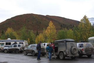
(Bert) We gather at the sign marking the start of the Dempster Highway. Steve
and Nancy, who will accompany us for the first few hours, take photographs of
those that will attempt the 734 km (456 mi.) gravel road: Jim & Donna, Bent &
Marie, Curt & Chris, John & Betty and Shari and me. Bill & Ginny already left
yesterday with their truck and 5th-wheel and we will meet them tonight. The rest
of us are driving two SUVís, a car and a Jeep. Weíve talked to many others that
have driven the road in other years or just as recently as yesterday and each as
a different opinion, ranging from ìthe worst condition it has ever beenî to ìyou
need high clearance to handle the deep potholesî to ìno problemî. It reminds
Shari and me of the first year we traveled the Cassiar Highway and the varying
advice we received beforehand. Weíve come to the conclusion that people describe
road conditions based on their experience of driving other roads and those who
have rarely stepped off an interstate will have a different opinion from those
that have free-wheeled mountain roads in Colorado or Mexico.
(Shari) Steve and Nancy are going the first 50 mi. with us, stopping at
Tombstone Territorial Park. We take a picture of our group at the start of the
road and joke about taking it again when and if we finish. So far the road is
good. A woman at Tombstone tells me that her motor home got stuck getting off
the ferry and had to be lifted up. She tells of slippery conditions and having
to drive down the middle of the road. She mentions the sides of the road are so
soft that they are caving in. ìJust go slow,î she says.
 (Bert)
The start of the road, up until Tombstone Territorial Park Campground, is the
worst part of the highway, especially this morning in the rain when shallow
potholes are filled with water and the gravel is a bit soft. Yet the road is no
worse than Top-of-the-world and Denali Highways. Beyond the dense spruce forest
we can see the more barren mountains of the North Klondike Range and then the
rugged Tombstone Range. From this distance, the jagged black rocks are
surrounded by a coverlet of mauve and green. While stopped at the Tombstone
Interpretive Center I photograph our car fleet, showing the mud that already
reaches up the sides and completely blocks the rear window.
(Bert)
The start of the road, up until Tombstone Territorial Park Campground, is the
worst part of the highway, especially this morning in the rain when shallow
potholes are filled with water and the gravel is a bit soft. Yet the road is no
worse than Top-of-the-world and Denali Highways. Beyond the dense spruce forest
we can see the more barren mountains of the North Klondike Range and then the
rugged Tombstone Range. From this distance, the jagged black rocks are
surrounded by a coverlet of mauve and green. While stopped at the Tombstone
Interpretive Center I photograph our car fleet, showing the mud that already
reaches up the sides and completely blocks the rear window.
(Shari) At every turn I expect to see Bill and Ginny on their way back (they
left a day early to allow for a slower drive). By 11 AM I wonder where these bad
road conditions are. So far the road has been a piece of cake and scenery truly
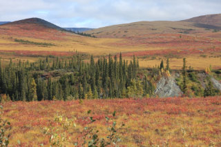
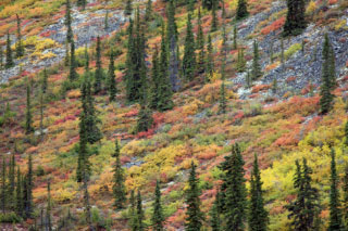
amazing. Within the first 50 mi. we pass three ecosystems. Although the skies
are gray, the landscape is beautiful with purples, yellows, reds and oranges
blanketing the tundra as far as the eye can see.
 (Bert)
Now the road leads to open country, with spruce forests allocated to small
patches against broad expanses of tundra. Fog stops us from seeing Tombstone
Mountain rising 14 mi. west of our viewpoint through a gap in the surrounding
mountains, many with crowns powdered white with snow fallen in the last few
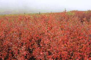
hours. We turn up a short side road to Goldensides, mostly because the
geocachers follow their GPS signal to this spot, about the highest point ñ at
more than 1250 m - reachable by road along the highway. Here we can see close up
what gives the mountains their fall colors: pinks, reds and oranges are stages
of Dwarf Birch photosynthesis withdrawal, yellows come from a variety of short
willow species, and hugging the rocky ground are the coagulated blood red of
Alpine Bearberry, petite plants growing densely enough to turn distant mountains
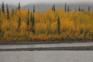
bloody. When we move on to lower elevations and especially along the streams and
rivers, the bright yellows of Balsam Poplar dominate and along the roadsides a
few remnant pink fireweed blossoms are shut out by the distinct red leaves and
stems of the majority. The evergreens of Black Spruce provide contrast at lower
elevations and in the distance at higher and steeper slopes the raw rocks of
black dolomite and the iron oxide red shale add to the splash of colors. Our
eyes are in overload at the grandeur surrounding us at every turn of the road.
(Bert)
Now the road leads to open country, with spruce forests allocated to small
patches against broad expanses of tundra. Fog stops us from seeing Tombstone
Mountain rising 14 mi. west of our viewpoint through a gap in the surrounding
mountains, many with crowns powdered white with snow fallen in the last few
hours. We turn up a short side road to Goldensides, mostly because the
geocachers follow their GPS signal to this spot, about the highest point ñ at
more than 1250 m - reachable by road along the highway. Here we can see close up
what gives the mountains their fall colors: pinks, reds and oranges are stages
of Dwarf Birch photosynthesis withdrawal, yellows come from a variety of short
willow species, and hugging the rocky ground are the coagulated blood red of
Alpine Bearberry, petite plants growing densely enough to turn distant mountains
bloody. When we move on to lower elevations and especially along the streams and
rivers, the bright yellows of Balsam Poplar dominate and along the roadsides a
few remnant pink fireweed blossoms are shut out by the distinct red leaves and
stems of the majority. The evergreens of Black Spruce provide contrast at lower
elevations and in the distance at higher and steeper slopes the raw rocks of
black dolomite and the iron oxide red shale add to the splash of colors. Our
eyes are in overload at the grandeur surrounding us at every turn of the road.
One stop that intrigues me is at Windy Pass summit, where the view is of
Eastern Beringia. Fog-shrouded, gently curved, barren, light gray limestone
slopes trend downward to a mauve valley sprinkled with a few short spruce.
Beringia, untouched by glaciers, little changed in the past 100,000 years, and
once connecting in the west to Asia, here I am staring at the land as it looked
when the nomadic First People crossed into North America.
 Would that I could spot a Wooly Mammoth wandering the dry, windy valley!
 Although
the fall season provides far fewer bird sightings than spring and early summer,
we get a good showing, especially of eight duck species including Ring-necked
Ducks whose breeding range is considered south of where we find them on Two
Moose Lake. Also on the lake, a Red-necked Grebe is a rarity according to the
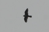
accounts Iíve read. The best birds are the two Gyrfalcons we find hunting the
cliffs near their now-abandoned nest.
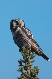
One soars above us with a Golden Eagle, a contrast in profiles. Chattering
behind us in the poplar are a half-dozen Boreal Chickadees. A couple of Northern
Hawk-Owls discovered in route are a delight. Iím surprised we see so few mammals
today, restricted to a bull Moose only seen by Bent and Marie and a couple of
Red Squirrels and a heard-only Arctic Ground Squirrel.
Although
the fall season provides far fewer bird sightings than spring and early summer,
we get a good showing, especially of eight duck species including Ring-necked
Ducks whose breeding range is considered south of where we find them on Two
Moose Lake. Also on the lake, a Red-necked Grebe is a rarity according to the
accounts Iíve read. The best birds are the two Gyrfalcons we find hunting the
cliffs near their now-abandoned nest.
One soars above us with a Golden Eagle, a contrast in profiles. Chattering
behind us in the poplar are a half-dozen Boreal Chickadees. A couple of Northern
Hawk-Owls discovered in route are a delight. Iím surprised we see so few mammals
today, restricted to a bull Moose only seen by Bent and Marie and a couple of
Red Squirrels and a heard-only Arctic Ground Squirrel.
Itís really the scenery, though, that keeps us spellbound. I fill my camera
with tiny fragments, narrow perspectives, and fuzzy composites of a vast
panorama that cannot easily be captured, but must be observed firsthand to
appreciate truly.
(Shari) We stop many times, drive slowly so as not to miss anything and do
not get to Eagle Plains until 7 PM ñ 12 hr. after we left this morning. Eagle
Plains is a surprise. A ìtownî with a population of 8 and services for the
traveler is open all year round. It is the halfway point on the highway with the
first buildings for over 200 mi. It has repair service, motel, restaurant, bar,
gift store, gas station, campground and government offices. We are hungry and
head to the restaurant first. Betty and John will be staying in a nice warm room
at the hotel with hot water and a TV. Bill and Ginny are here with their rig and
the rest of us will be sleeping in our cars. We have a good dinner before
heading to our cars for the night. The clouds have disappeared and the night sky
is clear. Ah, oh - that means cold. I hope to be snug in my flannel PJís and
sleeping bag rated to 40 degrees. Bert and I start to read but within 15 min.
get drowsy and fall asleep.
 (Bert)
Weíve traveled so slowly ñ not because of the road conditions, but to experience
the environment ñ that we do not reach Eagle Plains (pop. 8) until 7 PM. Here is
the first building, the first population, the first facilities since we left
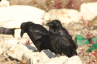
Tombstone Interpretative Center early this morning. Two ravens, huddled together
from the chilling winds blowing across the high ridge of the Eagle Plains
plateau ñ another unglaciated area of Canada - perch at the base of the sign
marking the elevation as 1985 ft. John and Betty check into the hotel while the
rest of us park our cars, move gear from back to front and set up air mattresses
and sleeping bags across the back of our SUVís and on the roof of the Jeep in
the case of Jim and Donna. Bill and Ginny are already comfortable in their
5th-wheel and describe the roads thus far as readily handled by their rig. We
gather for a delicious dinner at the surprisingly nice Eagle Plains Hotel, built
in 1978 for $3.5 million on solid bedrock and avoiding the shifting permafrost.
The temperature has dropped into the low 30s and the wind chill is severe when
we crawl into vehicles for the night.
(Bert)
Weíve traveled so slowly ñ not because of the road conditions, but to experience
the environment ñ that we do not reach Eagle Plains (pop. 8) until 7 PM. Here is
the first building, the first population, the first facilities since we left
Tombstone Interpretative Center early this morning. Two ravens, huddled together
from the chilling winds blowing across the high ridge of the Eagle Plains
plateau ñ another unglaciated area of Canada - perch at the base of the sign
marking the elevation as 1985 ft. John and Betty check into the hotel while the
rest of us park our cars, move gear from back to front and set up air mattresses
and sleeping bags across the back of our SUVís and on the roof of the Jeep in
the case of Jim and Donna. Bill and Ginny are already comfortable in their
5th-wheel and describe the roads thus far as readily handled by their rig. We
gather for a delicious dinner at the surprisingly nice Eagle Plains Hotel, built
in 1978 for $3.5 million on solid bedrock and avoiding the shifting permafrost.
The temperature has dropped into the low 30s and the wind chill is severe when
we crawl into vehicles for the night.
Day 96 - August 19 - Eagle Plains to Fort McPherson
(Bert) A word ñ COLD ñ would describe sleeping last night. Car windows
frosted from the inside as our warm breath condensed on the subfreezing windows.
At 5:30 AM I struggle out of the side door, shove my feet into untied weathered
SAS shoes and nimbly run to the warm bathroom. When we pack up and move the car
to the hotel lot I notice the rearview mirror thermometer registers the outside
air at 27∫. We survived well enough to repeat our makeshift car camping tonight.
(Shari) My goodness, the windows have ice on them and that ice is on the
inside. My sleeping blanket is stuck to the side of the car and the thermometer
reads 27∫. The hard part of sleeping in the car is getting in and out. Luckily I
did not have to go to the bathroom during the night and I stayed relatively
warm. Of course I slept with my jacket, hat and mittens on. If anyone looked in
our windows we must have been a sight. Bert gets out first, letting in gobs of
cold air. At least I have more room to maneuver with him out and I hop out as
quickly as I can, slipping on my shoes, gathering my washroom stuff and heading
for the warmth of the bathrooms at 6 AM. I meet Marie on her way out and Chris
inside intending to take a shower. After getting dressed I sneak into the hotel
lobby through a side door, as it does not open until 7.
(Bert) After a Yukoner breakfast of three eggs, bacon, ham, sausage, potato
patties, toast and three cups of hot tea, Iím ready for another day of
adventure. Only a few miles downhill, we stop at Eagle River, spanned by a
formidable metal bridge built on pilings driven through 35 ft. of permafrost.
Flocks of a dozen small birds scatter quickly and other singles disappear
without a trace into the bushy willows. We regularly see small birds, yet rarely
can identify them. Almost never perching in open view, nor stopping nearby,
these are the most skittish ìlittle brown jobsî weíve encountered throughout our
trip. When we do identify them, perhaps only 5% of those we see, they are:
Yellow Warbler, Yellow-rumped Warbler, Wilson Warbler, American Tree Sparrow,
Savannah Sparrow, White-crowned Sparrow, Dark-eyed Junco, Common Redpoll and
Pine Siskin.
(Shari) After a hearty breakfast we continue north on a beautiful, if cold,
sunshiny day. Our eyes feast on the fall colors of the tundra. I do not have
words to explain it, but I snap picture upon picture trying to capture the
scenes before me. I snap a picture of brilliantly red leaves etched in frost, I
pick low bush cranberries, I admire the orange and purple of the Dwarf Birch
trees and I thank God that I am alive to experience this landscape. Walking on
the tundra is like walking on a bog. The ground squishes under my feet and gives
way like a trampoline.
(Bert) Twice at cutbanks beside the road, we stop to examine the exposed
rocks, finding fossil plant fragments in the shale and fossil coral in
limestone, which I photograph, leaving the specimens for others to enjoy. It
seems odd to find evidence of a vibrant coral reef and lush plant life in this
harsh and seemingly barren landscape.
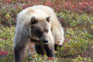
(Shari) We watch a Grizzly Bear make its way down a slope as it eats the many
berries ripe for the picking. We see a herd of caribou gathering for their trek
south. We get up close and personal to another pair of Grizzlies. Bert snaps
countless pictures as the bears approach us. I remember hearing that a bear is
too close if when you put your little finger up the Grizzly can be seen. I put
my thumb up and see the Grizzly. Heck, I put my whole hand up and still see the
Grizzly. I chicken out and decide to drive on. Betty and John are in the
approaching lane and Chris and Curt are approaching, but in my lane. I squeeze
between them in my haste for safety. Curt snaps pictures and I swear I think
that bear could reach into his car to take the camera. The bear does not seem to
care and calmly scratches his back on a highway post before crossing the road in
front of him. Later we see another Grizzly attempting to get at some garbage in
a dumpster but our cars chase it off up the hill.
 (Bert)
At 10 AM we cross the Arctic Circle, latitude 66∫ 33í N, at a mountain top
profusely adorned with a rainbow of autumn leaves, none raising more than a few
inches above the rocky ground, but lusciously proliferating in Lingonberries,
Dwarf Blueberries, Alpine Bearberries and Crowberries. Descending the road we
stop again for our first Grizzly Bear lounging against a hillside. The black
Grizzly is so fat it waddles awkwardly on spread haunches. We are traveling
through a broad valley flanked by the Richardson Mountains on the east the Rock
River on the west, the wintering grounds of the Porcupine caribou herd. We see
our first caribou alone, and then a bit farther a moving group of four. Then it
is a pair of blond Grizzlies feeding on tundra berries. First in the far
distance, slightly upslope of the flat valley, they move quickly, turning left
and right as they browse berry plants and making their way in our direction.
From the passenger seat, I am constantly taking photos as the telescopic views
get larger and larger until they fill the lens. Shari is getting nervous as the
big bears close in on our SUV. I want more photos; she wants to escape harmís
way, even though we are safely barricaded inside our car. Just as she pulls
away,
(Bert)
At 10 AM we cross the Arctic Circle, latitude 66∫ 33í N, at a mountain top
profusely adorned with a rainbow of autumn leaves, none raising more than a few
inches above the rocky ground, but lusciously proliferating in Lingonberries,
Dwarf Blueberries, Alpine Bearberries and Crowberries. Descending the road we
stop again for our first Grizzly Bear lounging against a hillside. The black
Grizzly is so fat it waddles awkwardly on spread haunches. We are traveling
through a broad valley flanked by the Richardson Mountains on the east the Rock
River on the west, the wintering grounds of the Porcupine caribou herd. We see
our first caribou alone, and then a bit farther a moving group of four. Then it
is a pair of blond Grizzlies feeding on tundra berries. First in the far
distance, slightly upslope of the flat valley, they move quickly, turning left
and right as they browse berry plants and making their way in our direction.
From the passenger seat, I am constantly taking photos as the telescopic views
get larger and larger until they fill the lens. Shari is getting nervous as the
big bears close in on our SUV. I want more photos; she wants to escape harmís
way, even though we are safely barricaded inside our car. Just as she pulls
away,
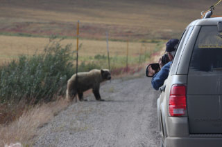 Chris
drives their SUV closer to the bears and Curt aims his long lens out of the
passenger window. One bear pauses at the roadside and vigorously scratches its
hindquarters against a stiff metal pole erected for marking the road edge for
snow removal vehicles. I turn to take a snapshot of Curt leaning out of the
window, aiming his camera, with the Grizzly against the pole and its head turned
toward Curt. Now it is back to the caribou again and this time we encounter a
herd of 14 galloping along the edge where flat valley meets hillside slope.
Some display huge racks extending from the tip of their nose to their shoulder
blades and rising above their heads almost as much as the distance from head to
foot. The odd single blade of the lowest branch of the rack is wide and extends
farthest forward, natureís design on a snow shovel for wintertime browsing.
Shari tries keeping pace with the galloping herd moving about 35 mph. We stop
when the leader turns his herd up the mountainside. What would be a vigorous
ascent for us is taken in stride by the caribou. The herd climbs across an
exuberance of pinks, reds and yellows, a softer vegetative pad that avoids the
sharper gray rocks offsetting the colorful mosaic.
Chris
drives their SUV closer to the bears and Curt aims his long lens out of the
passenger window. One bear pauses at the roadside and vigorously scratches its
hindquarters against a stiff metal pole erected for marking the road edge for
snow removal vehicles. I turn to take a snapshot of Curt leaning out of the
window, aiming his camera, with the Grizzly against the pole and its head turned
toward Curt. Now it is back to the caribou again and this time we encounter a
herd of 14 galloping along the edge where flat valley meets hillside slope.
Some display huge racks extending from the tip of their nose to their shoulder
blades and rising above their heads almost as much as the distance from head to
foot. The odd single blade of the lowest branch of the rack is wide and extends
farthest forward, natureís design on a snow shovel for wintertime browsing.
Shari tries keeping pace with the galloping herd moving about 35 mph. We stop
when the leader turns his herd up the mountainside. What would be a vigorous
ascent for us is taken in stride by the caribou. The herd climbs across an
exuberance of pinks, reds and yellows, a softer vegetative pad that avoids the
sharper gray rocks offsetting the colorful mosaic.
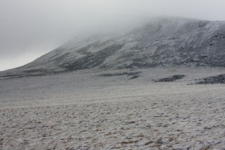 At
12:45 we reach the summit that marks the boundary of Northwest Territories and
move our clocks one hour forward, so much have we journeyed eastward as well as
northwardly. Stepping outside we face a snow blizzard and chilling wind that
makes us pull hoods up and insulated jackets tightly around us. Lustrously white
snow blankets the rugged mountain top, spreads across the gentle slope, clothes
the frigid willow shrub branches and widens grass stems threefold. Shivering, we
take photos of ourselves gathered at the territorial sign, marking evidence of
having passed this way. Calling raucously, a Common Raven is my first species of
Northwest Territories, appearing quite at home in the harsh weather. The
geocachers find yet another booty. Is their nowhere on Earth that is devoid of
caches?
At
12:45 we reach the summit that marks the boundary of Northwest Territories and
move our clocks one hour forward, so much have we journeyed eastward as well as
northwardly. Stepping outside we face a snow blizzard and chilling wind that
makes us pull hoods up and insulated jackets tightly around us. Lustrously white
snow blankets the rugged mountain top, spreads across the gentle slope, clothes
the frigid willow shrub branches and widens grass stems threefold. Shivering, we
take photos of ourselves gathered at the territorial sign, marking evidence of
having passed this way. Calling raucously, a Common Raven is my first species of
Northwest Territories, appearing quite at home in the harsh weather. The
geocachers find yet another booty. Is their nowhere on Earth that is devoid of
caches?
(Shari) We take pictures at a sign denoting the Arctic Circle. Jim, Donna and
I find two caches along the route and pick more berries. At the border between
the Yukon and Northwest Territories, we take more pictures, find another cache
and freeze our bodies in the chilled air. The ground is covered with glistening
white ice and cracks like glass under our feet.
 (Bert)
Today the August temperature hovers at freezing, bringing us snow at 30∫, icy
pellets at 34∫, sporadic rain and fog, mixed with sessions of clear and distant
views of landscape bathed in bright sunshine. Climbing through mountains,
descending into deep valleys, crossing rivers, caressing steep rock gorges, the
weather changes with the landscape and we enjoy all seasons in a single day.
After the boundary snowstorm we descend into a warm valley where the road
bounces over and around hills that make tossed spaghetti out of the road
pattern. No straight roads here!
(Bert)
Today the August temperature hovers at freezing, bringing us snow at 30∫, icy
pellets at 34∫, sporadic rain and fog, mixed with sessions of clear and distant
views of landscape bathed in bright sunshine. Climbing through mountains,
descending into deep valleys, crossing rivers, caressing steep rock gorges, the
weather changes with the landscape and we enjoy all seasons in a single day.
After the boundary snowstorm we descend into a warm valley where the road
bounces over and around hills that make tossed spaghetti out of the road
pattern. No straight roads here!
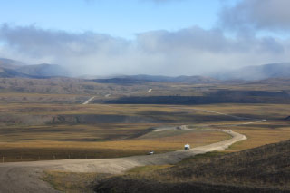
The Dempster drops 2800 ft., descending through a gorge and down to the Peel
River, 32 mi. away. In the narrow gorge with its shear slopes we can study the
mountain uplift, rough hewn rock markings tilted vertically 45∫ or more. A
shaggy and sooty brown Grizzly Bear prowls near a wayside container, perhaps
trying to find food. Upon our arrival it climbs up the steep tumble of rocks,
turning frequently to check us out. Farther on the Dempster we encounter a road
building crew with an array of earthmoving equipment rebuilding a portion of the
road, yet leaving a graded path for us to pass by. Leaving the Richardson
Mountains, at Peel River is our first ferry on the highway, a cable-driven
transit where Herring Gulls linger.
 (Shari)
As we descend, the temperatures warm to a whopping 37-39∫ and by the time we
stop for the night it is 42. We meet up with Bill and Ginny and share our pooled
food resources around their campfire. Hot dogs, chips, sausages, potatoes,
onions and lots of wine make a meal before bedtime. As we get ready for bed,
moving things to the front seat, we notice the air mattress has partially
flattened. Bert blows it up again and we hope it holds for the night.
(Shari)
As we descend, the temperatures warm to a whopping 37-39∫ and by the time we
stop for the night it is 42. We meet up with Bill and Ginny and share our pooled
food resources around their campfire. Hot dogs, chips, sausages, potatoes,
onions and lots of wine make a meal before bedtime. As we get ready for bed,
moving things to the front seat, we notice the air mattress has partially
flattened. Bert blows it up again and we hope it holds for the night.
(Bert) We stop at Nitainlaii Territorial Park for camping, while John and
Betty continue another 6 mi. to Fort McPherson for the hotel. Bill and Ginny are
already settled in camp and have a good fire burning. We share food that we have
brought with us, sample wine, comparing Curtís box wine to Shariís box vintage,
and delight in our primitive camping.
We are in Tetlit Gwichíin country and the man attending the campground says
his native language can be understood as far away as Fairbanks and a signpost
tells me its rudiments extend to the Apache in the south. Curiously, the fish
camps bordering the Peel River feature teepees in addition to rough-hewn wooden
structures where the local people smoke fish. Settlements in the Mackenzie River
delta have been in this area for 25,000 yrs. I also learn the correct
pronunciation of Inuvik, our goal for tomorrow, is ìinn NEW vickî.
Day 97 - August 20 - Fort McPherson to Inuvik
(Bert) Not as cold last night ñ it is 38∫ at 8:30 AM ñ we suffered another
camping experience when air completely exhausted from our mattress, leaving us a
hard bed. Billís hot fire is welcome as we gather for a campground breakfast. We
head to Fort McPherson to meet John and Betty and in light drizzle refuel at
$1.67/liter (approximately US$6.35/gal and surprisingly cheaper than the $6.76
we paid in Eagle Plains). Before leaving the Tetlit Gwichíin community (pop.
900), we stop at the Fort McPherson Tent and Canvas Company and from the
managerís explanation we come away impressed with quality and workmanship of
these superb tents that range from teepees to the type of tent housing you
expect to see on African safaris and are in fact used for plush accommodations
on $2000/day nature trips along the Yukon River.
Just north of the village, we stop between two lakes, one with a calling
Common Loon and the other with five Pacific Loons whose calls are mournful
catlike moaning. Three juvenile Horned Grebes are so young we wonder whether
they will develop flight feathers before succumbing to harsh weather. Tundra
Swan, Bald Eagle, Mew Gull, American Wigeon, Common Redpoll, the bird species
are thick here. Five Rusty Blackbirds perch atop spruce and we find farther down
the road. Then come five Spruce Grouse near Frog Creek, first on side of the
road, then timidly crossing and then in the willows on the opposite side, giving
us a great show. A Northern Pintail with chicks, two Long-tailed Ducks and then
a flock of 14 Pacific Loons with another across the lake continue the sightings
list.
Darkened lighting causes my photographs to be silver-toned, producing an unusual
artistic cast . At Mackenzie River crossing while waiting for the ferry I
photograph a Glaucous Gull and over the river fly two Sandhill Cranes.
 We
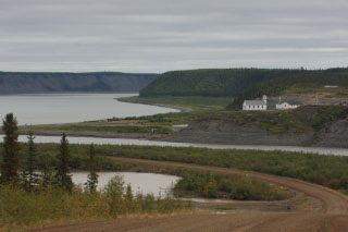
take the ferry first to Tsiigehtchic (pronounced ìsick ah chickî), at the
confluence of the Arctic Red River and the Mackenzie. Set on a hilltop is a
pretty church, the successor of a mission started here in 1868 at the site of a
traditional Gwichíin fishing camp. At the only grocery store in town we meet a
middle-aged man who moved here from southern Canada to run the store and now
likes this remote area so much he even stays during his vacation holidays. With
a little bit of everything, we buy soup and pizza sandwiches which we warm in
his microwave and I even buy a $2 Canadian stamp depicting a Peregrine Falcon
from the post office he runs in a corner closet of the store. He tells us that
his store and e-Bay are the chief suppliers of local goods.
We
take the ferry first to Tsiigehtchic (pronounced ìsick ah chickî), at the
confluence of the Arctic Red River and the Mackenzie. Set on a hilltop is a
pretty church, the successor of a mission started here in 1868 at the site of a
traditional Gwichíin fishing camp. At the only grocery store in town we meet a
middle-aged man who moved here from southern Canada to run the store and now
likes this remote area so much he even stays during his vacation holidays. With
a little bit of everything, we buy soup and pizza sandwiches which we warm in
his microwave and I even buy a $2 Canadian stamp depicting a Peregrine Falcon
from the post office he runs in a corner closet of the store. He tells us that
his store and e-Bay are the chief suppliers of local goods.
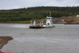
On the alternative ferry route ñ a triangular arrangement joining the three
shorelines of the river confluence ñ we cross to the continuance of the Dempster
toward Inuvik. Seeing the birderís emblem on my SUV, the ferry attendant points
to the vacated Cliff Swallow nests built under the wheelhouse and he tells us
that whenever chicks fell from the nest, the workers used a lift to put them
back into safety.
 We
stop again for Peregrine Falcon, Northern Harrier and to photograph Northern
Hawk-Owls. At the edge of Inuvik, near the airport, Ospreys occupy a nest built
on a tower, perhaps the northernmost nesting site for this species. This turns
out to be our best birding day on the Dempster, ending with 37 species.
We
stop again for Peregrine Falcon, Northern Harrier and to photograph Northern
Hawk-Owls. At the edge of Inuvik, near the airport, Ospreys occupy a nest built
on a tower, perhaps the northernmost nesting site for this species. This turns
out to be our best birding day on the Dempster, ending with 37 species.
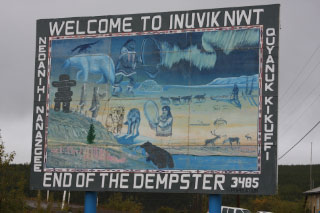
We have reached the end of the Dempster and Inuvik marks the end of
transportation northward by road. Here the Mackenzie River opens its delta to
the Beaufort Sea and the Arctic Ocean. After over 450 mi. of gravel road, almost
completely absent of people, Canadaís northernmost town of Inuvik looks like the
big city with its population of 3300, two hotels, and many government buildings.
(Shari) I can handle the cold, but I cannot handle a flat mattress. My night
was miserable and I did not sleep a bit. We hardly get out of the campground
today and I fall asleep in my seat as Bert drives. In Dawson City we each got a
passport book for the Dempster Highway. We are to get stamps at various places
on the route, then hand the completed stamped book in at the Visitor Center in
Inuvik. This will make us eligible for one of five prizes: a diamond, a gold
nugget, a carving, a painting or a T-shirt.
 Lots
of people miss the town of Tsiigehtchic because it is an alternate stop on the
same ferry that goes to Inuvik. The lady at the hotel Betty stayed at last night
reminded her not to forget it, but Betty did not quite understand her
directions.
Lots
of people miss the town of Tsiigehtchic because it is an alternate stop on the
same ferry that goes to Inuvik. The lady at the hotel Betty stayed at last night
reminded her not to forget it, but Betty did not quite understand her
directions.
This morning we make an effort to find out where to get the stamp, so we ask
the ferry worker on the Mackenzie River. He realizes that all five of our
vehicles want to go into town and he does not quite believe it. He asks more
than once, ìAll five of you?î He shouts to the captain and the captain does not
believe it either and has him repeat the number. So the ferry heads to the town
and we get off. We find the small grocery store and the man there tells us we
have to get our rubber stamps across the street. We head over there. By now we
are hungry so we go back to the grocery store. There is no restaurant in town
and we feel lucky to find a grocery. Bert and I find a refrigerated pizza
sandwich and one of those bowls of microwave Campbellís soup to buy. We heat
both up in the storeís microwave and eat our lunch in the car before getting on
the ferry again towards Inuvik and the end of the highway. The road becomes
pavement on the last 6 mi. and we feel like we have reached civilization,
especially when we see billboards and other cars. We check into a hotel and I
expect to sleep like a log. And I do.
 Day
98 - August 21 - Inuvik
Day
98 - August 21 - Inuvik
(Bert) After a good nightís sleep and a late start of 9 AM, we are primed to
hike the trail around Boot Lake. Although we find some birds ñ Pacific Loons,
Solitary and Spotted Sandpipers and a Blackpoll Warbler to name a few ñ the
highlight is a Red-billed Thrasher perched about 5 ft. up a short tree. Not one
to pass up this opportunity, Bent grabs the Thrasher and puts it on his head. A
couple hours later we stop at the Visitorís Center and museum. The two
attendants, both local residents, notice the red hat embroidered ìTHRASHERî and
ask Bent where he got it. Stunned and worried, Marie counter questions, ìWhy do
you ask?î Thrasher, it seems, is a local name. Bent reads the name inside the
hat, which includes a first name, and explains where he found the attractive
hat. Somewhat mystically, the attendants tell him that if he found it there, it
was the ownerís intent to loose it there. So, Bent replaces the colorful hat on
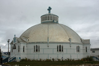
his head. Later we arrange to visit the locally famous Igloo Church, designed
without blueprints, built in the half-globe shape of a giant 3-story high,
double-walled, white igloo, complete with black block lines to connote ice
blocks and supported on an enormous disk that protects it from permafrost
shifting. Our guide points to a poster that describes the lady who drew the
ìStations of the Crossî paintings that adorn the walls. Iíll get to the punch
line in a minute, but first let me point out that the lady had no formal
training as an artist, yet was encouraged by the priest who said he thought she
would do a fine job. Indeed she did, and went on to a career as a professional
artist and at the time of the poster had completed 400 paintings. And, now, her
name: Mona Thrasher. An Internet search informs me that she was born in 1942 in
a bush camp between Aklavik and present day Inuvik, did the church paintings at
age 18, and on the website I view a painting of hers that sells for US$1500.
Bent follows the advice of the Visitorís Center worker and does not wear the
Red-billed Thrasher in the local pub.
(Shari) The birders and the geocachers split up. One group goes left and the
other right. Jim, Donna, Marie and I head for the cemetery to find the cache
that is under the end-of-road sign. This cache is one where you take down the
serial number of the travel bug nailed to the sign and send it over the Internet
for credit. After taking our pictures by the sign we join the rest of the group
on their bird walk. There are not many birds out this morning but the day is
nice. I find a few berries to pick before we break up for lunch and a free
afternoon. We meet again at Bill and Ginnyís campfire for a cookout. Some have
hamburgers, some sausages and some have pork chops cooked over the fire. We all
share in chips, fruit, coleslaw, beans, potatoes, onions and sausages and
cookies again with generous supply of wine. Just as we finish it starts to
drizzle and we pack up to retreat to our warm hotel rooms and the watch the
Olympics.
 Day
99 - August 22 - Inuvik
Day
99 - August 22 - Inuvik
(Bert) Intending to bird this morning, we head south of town, stopping to see
three Ospreys on the nest which I missed on our arrival. Rainfall dampens our
enthusiasm and keeps the birds under shelter, so we return to Inuvik, hoping to
see the Community Garden. No one seems to know when the enclosed garden is open,
in spite of two conflicting posted hours, and only after a few phone calls do we
set up an appointment to visit at 6 PM. Maryann meets us at the door and we soon
see she is a fount of information, not only about the gardens, but also about
the community, the First Nations people, the environment and almost anything
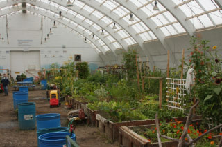
else we ask her. First we tour the Community Garden, a co-op venture where each
member pays $25 dues, rents one or two small plots at $50 each, and plants
whatever vegetables and flowers they choose. Sounds easy! Well, consider that no
native person has ever planted anything, the ground is permanently frozen just
below the surface, and even now in August temperatures have dipped below
freezing. The gardens are enclosed in a vacated ice hockey rink, with the
ceiling replaced by translucent sheets, giving nearly 24-hour sunlight and hot
humid temperatures. In fact, in summer months the temperature can be so high as
to induce heat stroke on gardeners were it not for the ventilation system they
designed. Dues and rental, up to $125, may seem high compared to the rewards
until you realize the price of vegetables is two to three times normally high
prices. Maryann estimates she produced $700 worth last season.
The conversation drifts to environmental issues and we find out Maryann is an
environmental consultant acting as an intermediator between oil interests and
First Nations people sustaining subsistence living and she experiences the
conflicts it ensues. Global warming has caused ice to melt in areas that
historically were iced shut, denying Polar Bears the ice islands used in their
pursuit of seals. The Polar Bears have left the area and headed to Greenland,
which now has a surplus. Meanwhile the seal population exploded, overharvested
the fish and destroyed the subsistence fishing of the native population.
Likewise, the iced bays once closed to whales are now open in summer months,
permitting the whales to move inland. Unfortunately, the whales do not know they
must leave the area before the bay freezes its opening to the sea and in each of
the past two years 200 whales died. Considering that subsistence hunting of
whales in Barrow was legally limited to only about 10 whales, reduced for fear
of hunting exceeding reproduction, the loss of 200 whales per year to global
warming just at Inuvik seems overwhelming. No fish to fish, no whales to harpoon
ñ what about caribou? Members of the Porcupine caribou herd drastically dropped
in number. Although no one knows for sure what happened, one likely possibility
is that the First Nations people leased part of their land to diamond miners.
The mining efforts disrupted the caribou migration, so much so that the lease
was rescinded, although the matter now must be settled in the courts. Maryanne
went on and on, prompted by our questions. Now oil interests are high, with talk
of constructing a pipeline for transporting from new wells to be drilled in the
delta area and offshore in the Arctic Ocean. Oil money could be a bonanza for
the local economy, bring thousands to the oil fields, boosting employment and
filling the coffers of the local bands. Yet, the environmental disasters that
could easily occur with offshore drilling in the harsh and unforgiving Arctic
Ocean, the disruption of wildlife such as the caribou, the concomitant
interference with the subsistence living of a First Nations people who have
lived this way for thousands of years is so overwhelming a problem as nearly to
defy solution.
(Shari) We try to hike this morning but the rain wonít let us. We throw in
the towel about 10:30 and decide to go to the visitor center to watch a movie.
We fill their small room and as we sip tea and coffee we spend the next hour
learning about Canadaís Land of the Midnight Sun. Then we watch a movie about
the Dempster Highway. I think our experience on it was better than the movie and
that 60 Minutes should do a segment about our group. After lunch we try again to
see the town gardens but in spite of what the Visitor Center said, they are
closed. We go to the town center and get Inuvik pins. The young man there makes
a few calls and soon we are having a private tour of the Igloo Church and at 6
PM a tour of the gardens. Maryann is our tour guide at the gardens and she
fascinates us for almost two hours, not only about the gardens but also about
the culture and environment of the area. She is an environmental consultant and
has been here for 18 months. She sees the clash between a people that live off
the land and the modern ways. She says it is inevitable that oil will open up
the wilderness. She hopes for minimum impact. She tells us of how Polar Bears
are now in Greenland due to lack of ice near Inuvik. Therefore the seal
population is exploding and fish are scarce. No caribou made their migration
last year. 200 whales could not get out of a river and died. A rare thunderstorm
scared the First Nations people so much that they had a tribal meeting to
discuss it. Alcohol is a big problem in a society where self worth is measured
by food on the table not words read in a book. The government is trying to
retrain but I wonder how successful it can be. For example the gardens have been
operating for 5 years and most of the 120 plots are rented by government
employees wanting fresh vegetables. For $50 plus a $25 membership fee, one can
have a 6x6 plot of ground to set plants. People are growing corn, lettuce,
cucumbers, squash, beans, beets, carrots, tomatoes and even green peppers in
their plots. Maryann says she had saved close to $700 with her two plots last
year. After our tour Bert and I have a pizza delivered to our room. Munching
pizza we alternate watching CNN and the Olympics on the TV.
Day 100 - August 23 ñ Inuvik to Eagle Plains
(Bert) We agreed to leave Inuvik at 7:30, but are still waiting to check out
at the hotel at 7:50. Only one clerk is on duty and he is so drunk that he
cannot push the buttons on the credit card machine, cannot focus on the charge
receipt and cannot produce the correct amount that we owe. After more than a
half hour of failing to reach a final bill for anyone except Shari who checked
out early, we each ask for a business card for the hotel manager and promise to
call him and explain why we have not paid. Alcoholism among First Nations and
Native American peoples is a significant problem in many northern towns and we
have seen obvious evidence of it in Gambell, Nome, Barrow and Inuvik. There
undoubtedly are many causes, but the disruption of a subsistence society and the
attempts by outsiders to force them to mold into our lifestyle certainly is a
major factor. I remember on our 2000 trip to the Canadian Maritimes visiting a
church in Quebec and hearing of the lawsuits against the church for sexual
misconduct in the schools to which the government forced the First Nations
children to attend, after removing them from their homes. Yesterday, I asked
Maryann about the outcome of that lawsuit. Not only did the actions disrupt
families and remove children from parental guidance and training in traditional
ways, but also the $15,000 each offended person collected was often fritted away
on booze and drugs by social misfits. Even traditional roles such as caribou
hunting are disrupted, since the affected, now middle-aged, population did not
receive adequate training and now, instead, shoot at out-of-range caribou and
fail to retrieve wounded animals. We have seen posted signs in Inuvik in an
education program to reform these misguided hunting practices.
We drive faster today, typically 40-45 mph on roads that could safely sustain
50-55 mph. Only pausing briefly for wildlife, we nonetheless record Spruce
Grouse, Gray Jay, Northern Flickers, Tundra Swans and two Northern Hawk-Owls in
the first 90 min. At Rabbit Creek I appropriately see a Snowshoe Hare and
observing a second one 10 mi. farther I notice the hares are already turning
white ñ from the bottom up ñ for the pending winter season. Even with the later
start, we reach the Mackenzie River ferry when it begins operation at 9:30,
though one minute late and must wait 20 min. for it to make the triangular
circuit.
 Driving
through the boreal forest of the Mackenzie River delta, we encounter Spruce
Grouse repeatedly: first the two, then a group of five followed quickly by five
more, and then a single. At Fort McPherson one of the immature non-flying Horned
Grebes is on the same pond. Itís warmer today at 37-43∫, so maybe the grebes
will survive to migration. A Northern Bog Lemming scurries across the road: an
elongated blackish densely furred rodent with a very short tail. We ferry across
the Peel River and start the climb into Richardson Mountains. At Wright Pass we
see the only two caribou of the day as they trot slowly across the vast valley
below.
Driving
through the boreal forest of the Mackenzie River delta, we encounter Spruce
Grouse repeatedly: first the two, then a group of five followed quickly by five
more, and then a single. At Fort McPherson one of the immature non-flying Horned
Grebes is on the same pond. Itís warmer today at 37-43∫, so maybe the grebes
will survive to migration. A Northern Bog Lemming scurries across the road: an
elongated blackish densely furred rodent with a very short tail. We ferry across
the Peel River and start the climb into Richardson Mountains. At Wright Pass we
see the only two caribou of the day as they trot slowly across the vast valley
below.
We have been noticing the color changes that occurred in the few days since
we passed here. Tamaracks which were green on our northern passage are mostly
golden yellow now and the Prickly Rose leaves have turned plum red. We see two
Grizzlies today; these are black with golden guard hairs. They browse for
berries amid a multicolor tundra blanket, paying no attention to our stopped
vehicles. Stopping to pick berries at the Arctic Circle I take photographs of
the landscape which is now even brighter in fall colors. When we arrive at Eagle
Plains we find a note that Bill and Ginny have moved on ahead of us.
Day 101 - August 24 ñ Eagle Plains to Klondike Highway
(Shari) With the new mattress stacked above the old half-deflated one, only 2
feet separates us from the carís ceiling, making it difficult to roll over.
Ironically, now that we got the new air mattress, the old one does not leak.
Last night Bert had to get out and uncap the nozzle to release some air. Luckily
I did not have to get up during the night again since getting in and out of the
car is so painful. I sleep pretty well and the alarm wakes me. It is not as cold
as last time we were here, the thermometer reading 34∫ this morning. I walk to
the warm washroom and wash my face and brush my teeth. By the time I return,
Bert has all things moved from the front seat to the back, ready for travel. I
ask him where my camera is since I did not want to sleep on it last night and
took it out of my pocket. We cannot find it anywhere and he cannot find his
keys. He uses my keys and I use his camera, both of us worrying that we may have
lost them.
 (Bert)
Even though it is drizzling, I want to stop at the KM237 Airstrip to see if we
can find the Great Gray Owl nesting near there. We do not, instead finding a
half-dozen Boreal Chickadees. When Jim plays an owl recording, he attracts a
curious raven.
(Bert)
Even though it is drizzling, I want to stop at the KM237 Airstrip to see if we
can find the Great Gray Owl nesting near there. We do not, instead finding a
half-dozen Boreal Chickadees. When Jim plays an owl recording, he attracts a
curious raven.
The intensity of fall colors must be close to its peak today. The Balsam
Poplars along the rivers and in the wetlands are sulphurous torches, painting
broad swatches of yellow in all the lower elevation areas. Not the work of a
timid artist in pastels, against the mountain slopes the tapestry is painted in
vibrant, almost gaudy, broad splashes of pink and red and big dabs of yellow and
orange, with nary a spot absent of bold colors.
 (Shari)
After a wonderful hearty breakfast, we are on the road. We make few stops today
and make good time, often traveling 45 to 50 mph on the gravel road. Sometimes
the gravel is like asphalt, both in look and feel. Sometimes it is dusty, yet
rarely bad. Soon the rain returns, hiding the sun. However, the yellow leaves of
the poplars along the road are so brilliant that they make their own sun. We
thought on our way up the fall colors were at their peak. I guess not, since now
whole mountains are awash with paint. God must have lingered with His brush on
this landscape since it is so ìdrop dead gorgeousî. I have never seen anything
like it. Whole mountains are covered with red. Turn the corner and then they
glisten in a coppery orange. This color is not just a patch here and there but
acres upon acres ñ no, miles upon miles ñ of varying hues. As far as the eye can
see, the landscape feeds us a menu to delight the eye. Hour after hour I ooh and
ah, like a kid at 4th of July fireworks. One whole mountain looks like a marbled
red, orange and yellow cake with rivers of green tumbling down the valleys and
frosted with grayish black icing. I donít think I have the words to describe the
picture. Bert will do better but I bet our pictures wonít even capture the
spectacular beauty, because we are surrounded in color all day long.
(Shari)
After a wonderful hearty breakfast, we are on the road. We make few stops today
and make good time, often traveling 45 to 50 mph on the gravel road. Sometimes
the gravel is like asphalt, both in look and feel. Sometimes it is dusty, yet
rarely bad. Soon the rain returns, hiding the sun. However, the yellow leaves of
the poplars along the road are so brilliant that they make their own sun. We
thought on our way up the fall colors were at their peak. I guess not, since now
whole mountains are awash with paint. God must have lingered with His brush on
this landscape since it is so ìdrop dead gorgeousî. I have never seen anything
like it. Whole mountains are covered with red. Turn the corner and then they
glisten in a coppery orange. This color is not just a patch here and there but
acres upon acres ñ no, miles upon miles ñ of varying hues. As far as the eye can
see, the landscape feeds us a menu to delight the eye. Hour after hour I ooh and
ah, like a kid at 4th of July fireworks. One whole mountain looks like a marbled
red, orange and yellow cake with rivers of green tumbling down the valleys and
frosted with grayish black icing. I donít think I have the words to describe the
picture. Bert will do better but I bet our pictures wonít even capture the
spectacular beauty, because we are surrounded in color all day long.
 (Bert)
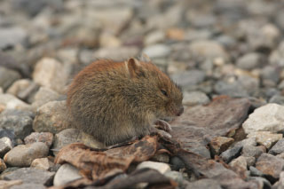
At our lunch stop at a highway maintenance pullout I see a mouse-like rodent
scurrying across the broad gravel lot. I run up with my camera in hand, as the
exposed animal has no close place to escape and these rodents are usually so
fast that it is hard to get a good look at one, even though they are common.
Itís a Northern Red-backed Vole and I block its path while snapping photos. I
try to take one last shot when it runs between my legs and into the bush.
(Bert)
At our lunch stop at a highway maintenance pullout I see a mouse-like rodent
scurrying across the broad gravel lot. I run up with my camera in hand, as the
exposed animal has no close place to escape and these rodents are usually so
fast that it is hard to get a good look at one, even though they are common.
Itís a Northern Red-backed Vole and I block its path while snapping photos. I
try to take one last shot when it runs between my legs and into the bush.
The birds are again our favorites: Spruce Grouse, Willow Ptarmigan, Northern
Shrike (Chris and Curt only), Northern Hawk-Owl and Boreal Chickadee. My best is
a Sharp-shinned Hawk dancing aerially over the road in front of the car. We hit
a bonanza of ducks at Two Moose Lake, all receded to the far side of the thaw
lake. Through the spotting scope I identify 1 Mallard, 6+ Ring-necked Ducks, 1
Greater Scaup, 4 Lesser Scaup, 1 Long-tailed Duck, 4 Bufflehead, and 1 Barrowís
Goldeneye.
(Shari) As we make our descent from our final mountain, the thermometer reads
43∫. Curt radios that it is a regular heat wave. Back at our RVís at the end of
the Dempster Highway, we wash the terrible mud from our cars and put away our
stuff. Bert finds my camera and his car keys lying under the sleeping bags.
Exhausted and showered, we hop into a nice warm big bed dreaming of a wonderful
time in one of the last wildernesses left on earth.
 Next
Day
Next
Day  Table
of Contents
Table
of Contents